
Computer Vision for Precision Agriculture: Mapping Fields from Space
Satellite data has become an invaluable resource for a wide range of applications, and agriculture is no exception. With the increasing availability of high-resolution imagery, we can now leverage the power of computer vision to gain advanced insights into agricultural practices. One particularly impactful application is the automated mapping of agricultural fields.
The Power of Computer Vision
Computer vision, a field of artificial intelligence, enables computers to “see” and interpret images much like humans do. By training algorithms on vast datasets of satellite imagery, we can teach them to identify specific features, such as the boundaries of agricultural fields.
Automated Field Mapping: A Game Changer
Traditionally, mapping agricultural fields has been a time-consuming and labor-intensive process, often relying on manual digitization or ground surveys. Computer vision offers a much more efficient and scalable solution.
- Efficiency: Algorithms can process large volumes of satellite data in a fraction of the time it would take a human.
- Accuracy: Well-trained models can achieve high levels of accuracy in delineating field boundaries.
- Scalability: The process can be easily scaled to cover vast agricultural regions.
- Timeliness: Satellite data can be acquired frequently, allowing for up-to-date field maps.
How it Works
The process typically involves the following steps:
- Data Acquisition: High-resolution satellite imagery is acquired for the target region.
- Preprocessing: The imagery is preprocessed to correct for geometric distortions and atmospheric effects.
- Model Training: A computer vision model, such as a convolutional neural network (CNN), is trained on a dataset of labeled satellite imagery, where field boundaries have been manually annotated.
- Field Delineation: The trained model is applied to the satellite imagery to automatically delineate field boundaries.
- Post-processing: The results are post-processed to refine the boundaries and remove any errors.
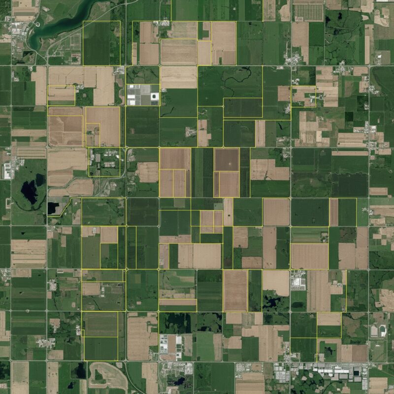
Visualizing the Results
Here’s an example of a satellite image with bounding boxes highlighting the automatically mapped agricultural fields:
Benefits and Applications
Automated field mapping has numerous benefits and applications:
- Precision Agriculture: Provides crucial information for optimizing irrigation, fertilization, and pest control.
- Crop Monitoring: Enables the tracking of crop growth and health over time.
- Yield Estimation: Supports more accurate yield forecasting.
- Land Use Management: Facilitates better planning and management of agricultural land.
- Policy Making: Provides valuable data for agricultural policy development.
Conclusion
Computer vision is revolutionizing the way we understand and manage agricultural landscapes. By automating the mapping of agricultural fields from satellite data, we can unlock a wealth of information that can lead to more sustainable and efficient agricultural practices.
Would you like to explore other applications of computer vision in agriculture or delve deeper into specific aspects of this technology?


